|
|
|||||||||||||||||||||||||||||||||||||||||||||||||||||||
|
|
|
||||||||||||||||||||||||||||||||||||||||||||||||||||||
|
|
|||||||||||||||||||||||||||||||||||||||||||||||||||||||
By CarHighways
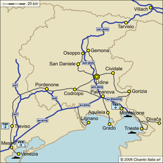
Although Italian public roads are good, if you drive from outside Udine we recommend the highway (motorway, or "autostrada" in Italian) as the fastest and safest option. Italian highways are marked by green road signs (i.e. not blue as in other countries), and are toll-supported (i.e. you have to pay when you exit). The speed limit for cars on Italian highways is 130 km/h (limits may be lower in case of rain, snow or fog). On highways and major roads headlights must be on at all times (day and night). Motorbikes must have their lights turned on on all roads (not just highways). South of Udine, A23 intersects and merges with A4, which is the highway which follows the coast from Venice (Venezia), in the south, to Trieste and Slovenia in the east. This three-highway junction (as you can choose to take A23 north, A4 east or A4 south) is located near the town of Palmanova. Entry and Exit LanesAt all highways in the region (like almost everywhere in Italy) you must collect a ticket (don't lose it) when you enter the highway, and pay when you exit. Please note that yellow "Telepass" entry and exit lanes are reserved for cars enabled for this electronic toll collection system. If you use such a lane without a Telepass device you will not be able to pass (unless the same gate is also enabled for other payment systems, which case would be appropriately marked). Credit cards are accepted at all other gates. Computer-Assisted NavigationAll event-related venues are in Udine.
From the NorthIf you come from Austria (via Villach/Arnoldstein) you will enter A23 through Tarvisio. To go directly to the event venue: pass "Udine nord" (do not exit there) and exit at "Udine sud". For south downtown (train station area): pass "Udine nord" (do not exit there) and exit at "Udine sud". Follow "Directions from A23 to Piazza Primo Maggio". From the EastIf you come from Trieste or Gorizia (or TRS airport) take A4 towards Venezia (Venice) and Udine, and turn right on A23 to Udine. To go directly to the event venue: exit A23 at "Udine sud". For south downtown (train station area): exit A23 at "Udine sud". From Slovenia you can enter Italy through Trieste (Trst), Gorizia/Nova-Gorica, Tarvisio (A23 via Karawankentunnel in Austria, or through mountain roads), Cividale (road G102 in Slovenia to road SS54 in Italy) and several other routes. If you take SS54 you will end up in Via Cividale (see the event neighborhood map), which is near the 2007 event bus stops and hotel. If you come from Ljubljana we recommend the A1/A3 highway route via Trieste Fernetti (Fernetiči) border post. Immediately after the border post follow the green A4/A23 highway signs to Udine. The whole journey should take about 90 minutes. Follow "Directions from A23 to Destination". From the SouthIf you come from Venice or Treviso (including VCE or TSF airports) take A4 towards Trieste and Udine, until you see the sign to turn left for A23 to Udine and Austria. To go directly to the event venue: exit at "Udine sud". For south downtown (train station and hotel area): exit at "Udine sud". Follow "Directions from A23 to Piazza Primo Maggio". Directions from A23 to Piazza Primo Maggio
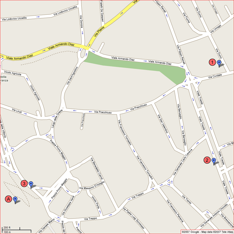
Saturday's bus departs at 09:00 from Piazza Primo Maggio ("3" on the map). The bus also stops at the hotel ("1") at 08:50 and at the theater parking lot ("2") at 08:55. Piazza Primo Maggio ("first of May square") is the final stop of the event bus before leaving Udine. Aim to be there no later than 08:40, as you may need some time to park the car and find the bus stop.
Directions from A23 to South DowntownThe following directions will guide you from the highway to the train station area. This is not the shortest route (it would be possible to shave off another km or so), but it is the one with the clearest indications and the best points of reference in case you get lost.
ParkingIn general, parking areas along the sides of local roads may be delimited by white, blue or yellow stripes. White indicates free parking. Blue is free during the night and on Sundays (and around midday, in some areas), whereas a ticket is required during the hours indicated by the signs near the ticket vending machines. Yellow is for holders of special permits. The event venue map includes several free parking areas next to the event. The south downtown map contains a reference to a large parking area behind the train station (marked by "6"). This two-floor parking lot is reserved for subscribers at the ground floor, and costs only EUR 1.60 for 12 hours at the upper floor. From South Downtown back to A23On your way back to A23 follow the "B" arrow on the south downtown map, which is immediately followed by a green "Autostrada" sign. Keep in mind that Viale Europa Unita, Via I. Nievo, Via R. Battistig, Via Roma and Via T. Ciconi are one-ways and can be driven only counterclockwise (Via T. Ciconi going west, the others going east or north). When you reach Piazzale Cella stay on the left lane and follow the first green "Autostrada" sign for A23. Ignore all blue signs saying "Tarvisio", "Austria", etc., unless you prefer to visit some of the shopping malls along the road and enter the highway in Udine nord or Gemona. After the pedestrian crossing in Piazzale Cella you will see other two green "Autostrada" signs, one directing you to the right for Tarvisio and Austria (i.e. north), the other straight ahead for Venezia and Trieste (i.e. south and east). Maps and Directions SitesFor additional maps and for detailed route planning information we recommend the following sites: Rental CarsYou can rent a car both at airport locations and in the train station neighborhood. Buses are also available. |
|||||||||||||||||||||||||||||||||||||||||||||||||||||||